
 Hiking, by Orma Logbook
Your hiking.
Your distance and your elevation gain outing by outing, your high point with its milestones, your multi-day treks step by step, and the grades of the FFRandonnée and the Swiss Alpine Club side by side. In a logbook that holds your other sports too.
Get it on Google Play Coming soon to the App Store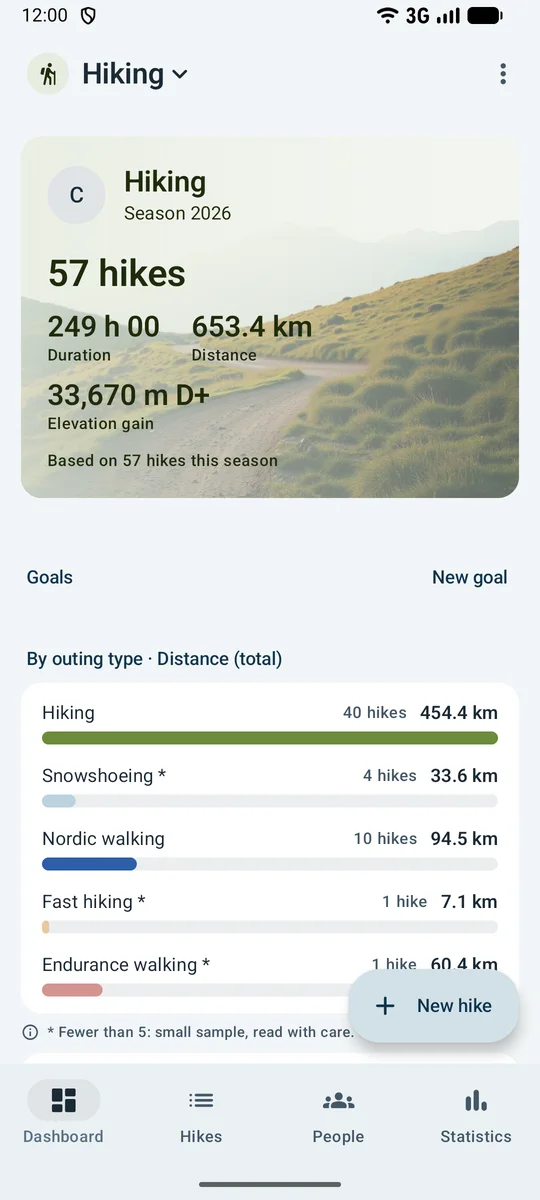
-
17.2 km · 1,450 m D+
Three figures, and it is noted
The date, the distance and the elevation gain are enough; the rest is optional and folded away. The elevation gain per kilometre works out on its own, and the average speed reads on the outing’s page.
-
- Hiking
- Snowshoeing
- Nordic walking
- Fast hiking
- Endurance walking
- Sea walking
- Via ferrata
7 outing types
From hiking to via ferrata, through snowshoeing and Nordic walking: each type opens its own grades and is read apart in the statistics.
-
- T1
- T2
- T3
- T4
- T5
- T6
T1 to T6, and the FFRandonnée’s triplet
The Swiss Alpine Club scale describes the terrain, half-levels included. The FFRandonnée’s effort, technicity and risk are graded apart, each on five levels, never blended into one grade.
-
- R grade
- SAC scale (Wintertrekking)
Snowshoeing, 2 scales
R1 to R5 for the French guidebooks, WT1 to WT6 for the Swiss Alpine Club: they are noted side by side, without conversion, with the avalanche bulletin.
-
First 3,000 m
The milestones, announced
The first 3,000 m and the first 4,000 m reached, the first day at 1,000 m then at 2,000 m of elevation gain: the logbook announces them when they fall. “Records” adds the longest outing in duration.
-
- Back the same day
- Mountain hut
- Walkers' hostel
- Bivouac
- Hotel
From the hut to the hotel
Each stage of a multi-day trek is filed under its event, with its lodging and its nights. The trek’s page adds up kilometres, elevation gain, time and nights.
-
- GR long trail
- Regional GR loop
- Local waymarked path
- Mountain path
- Local waymarking
- Off trail
Waymarking, a real hiker’s word
GR, regional GR, PR, mountain path, local waymarking or off-trail: “how many kilometres of GR this year” gets its answer.
-
- 25 km
- 50 km
- 75 km
- 100 km
- 125 km
- 150 km
Endurance walking certificates
The certificate aimed for, from 25 to 150 km, and its official approval: you earn it or you do not, with no ranking and no winner.
More than 1,500 ways to read your hiking
15 ready-made analyses, and custom analysis: 54 indicators to cross with 28 criteria, as a breakdown or over time, with whatever filters you like.
- 15ready-made analyses
- 54indicators
- 28criteria
- 1,512possible combinations
- Your kilometres walked, month by month
- Your cumulative elevation gain, month by month
- The number of outings of each type
- Your highest point, year after year
- The kilometres covered on each type of waymarking
- The number of outings by Swiss Alpine Club grade
- Your average elevation gain per kilometre by outing type
- The number of turn-backs by reason
- The number of outings done to their objective, and of turn-backs
- The nights of each trek
- The distance of your longest outing, year after year
- The time spent outdoors, month by month
- The average elevation gain of an outing by route shape
- The number of snowshoe outings by avalanche bulletin level
- Your average heart rate by outing type
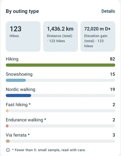
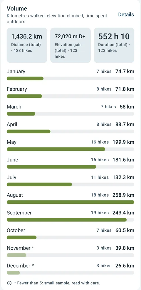
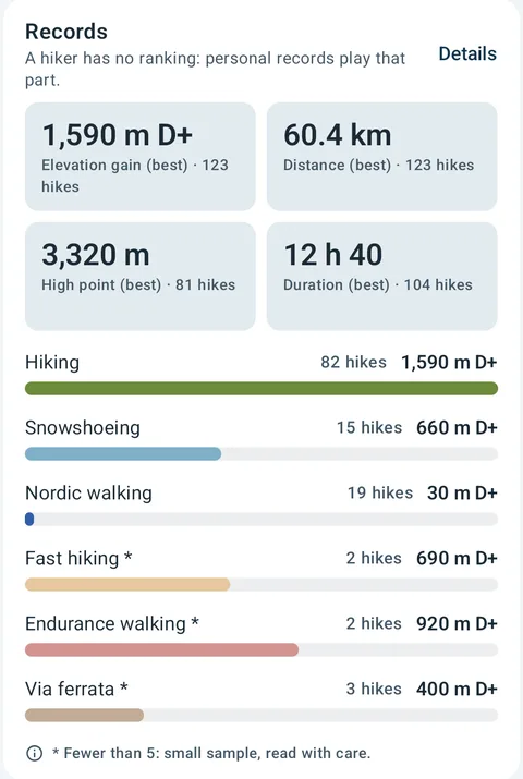
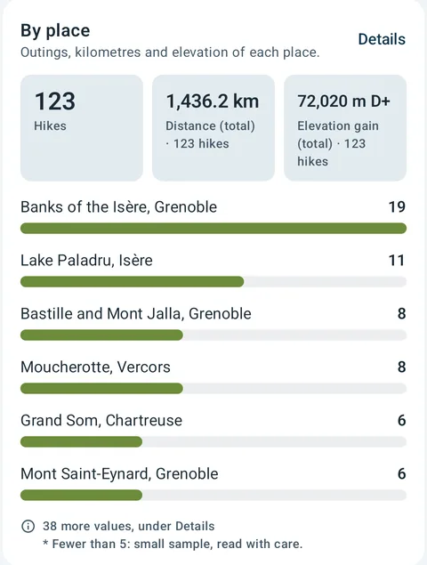
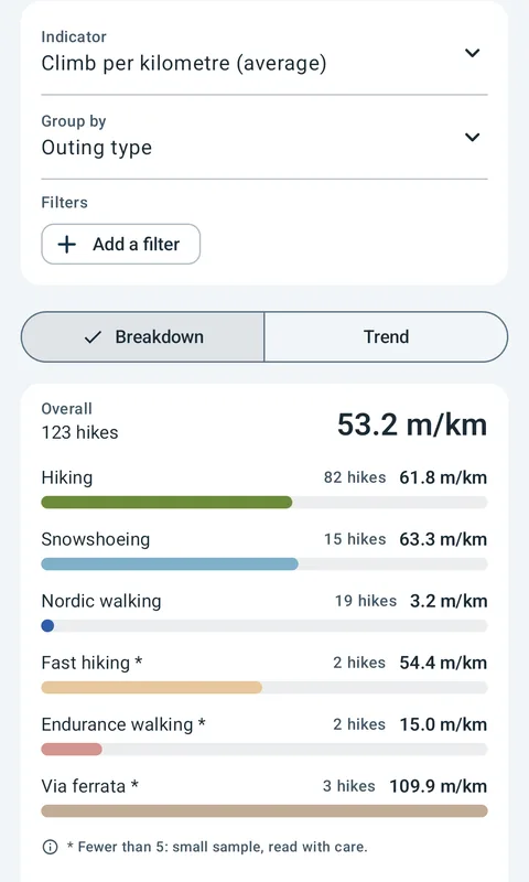
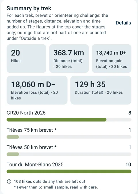
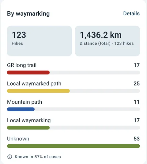
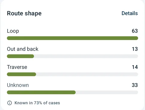
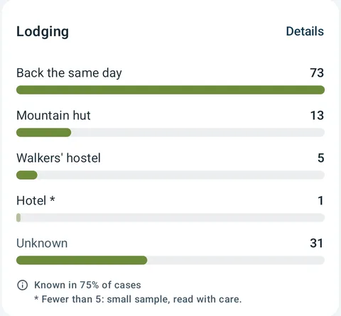
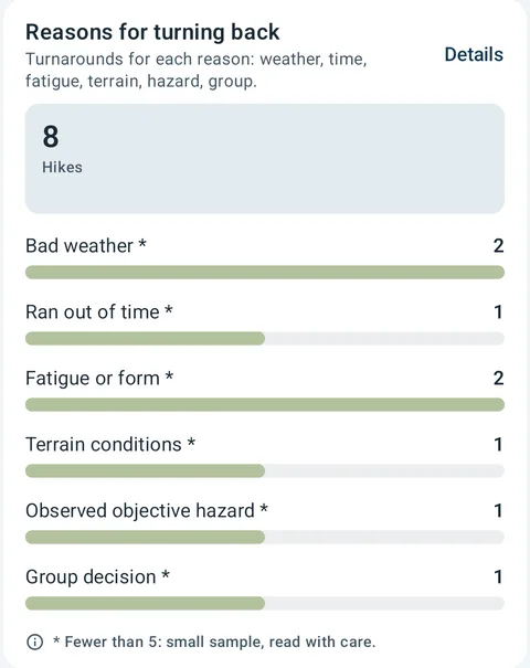
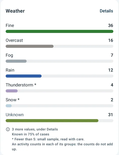
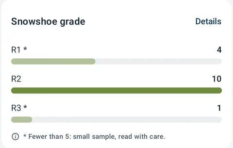
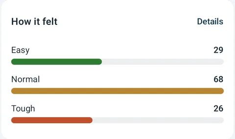
Tap a bar, a slice or a point: the hikes behind it open up. And every figure says how many hikes it is based on.
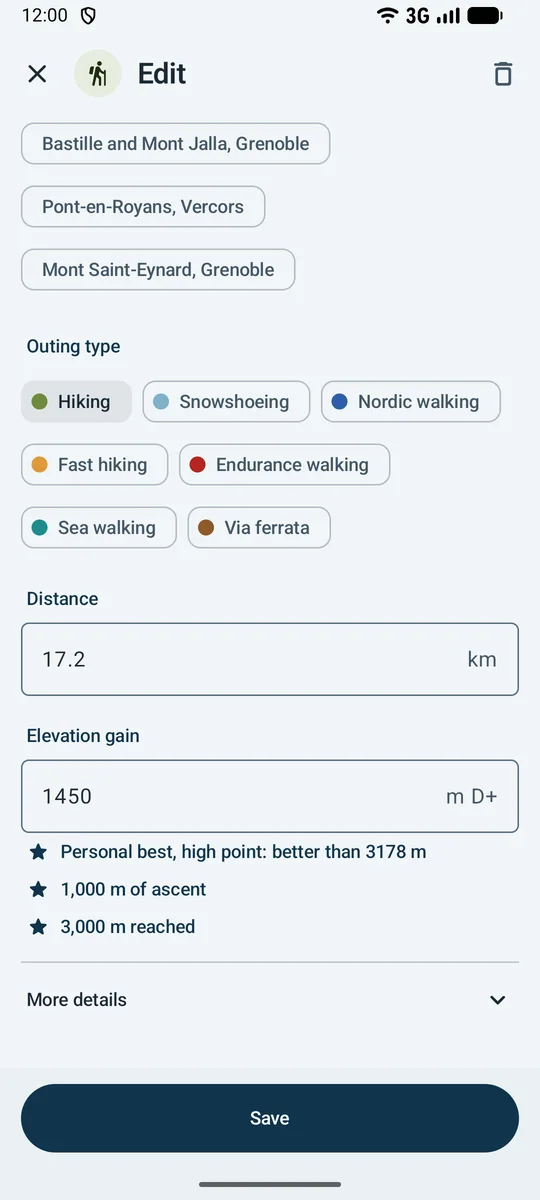
The type, the distance, the elevation gain: that is all
The outing type, the distance and the elevation gain are in front of you; the high point, the waymarking, the grades, the lodging and the weather unfold when you want them.
Hiking · 17.2 km · 1,450 m D+- “Hiking” by default: snowshoeing, Nordic walking, fast hiking or via ferrata are picked with one tap.
- The elevation gain per kilometre and the average speed are calculated.
- “Fill from a GPX file” takes over the times, the distance, the elevation gain, the high point and the heart rate of a track.
- Milestones are celebrated as you enter them: a high-point record, 1,000 m of ascent, 3,000 m reached.
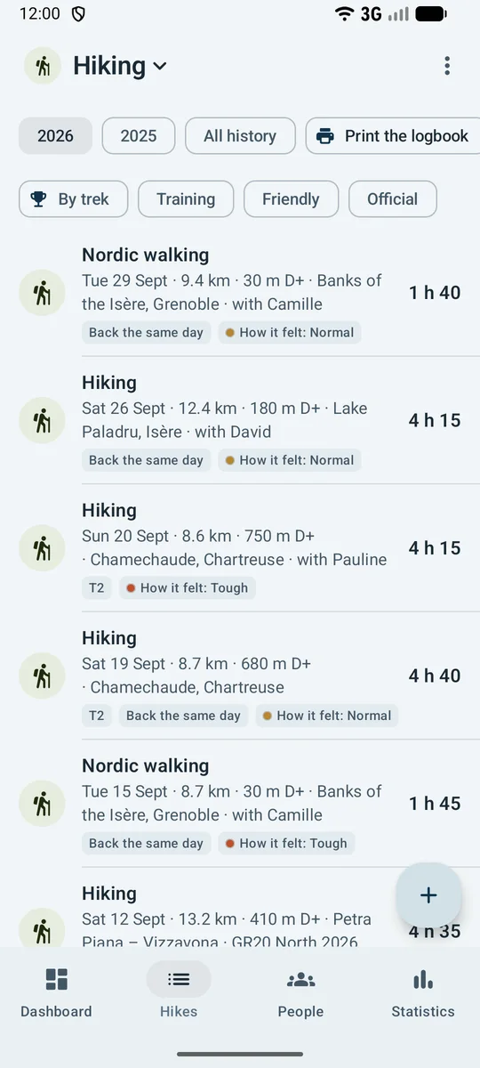
Your outings, with their elevation gain
Each outing gives its type, its distance, its elevation gain, its place, its grade, its lodging and the feeling, newest first.
- A multi-day trek has its own page: stages, kilometres, elevation gain, time and nights.
- Speed is never on the line: it reads on the outing’s page.
- Who came along reads on the line: “with Camille”, “with David”.
- Seasons are chosen at the top of the list, and “All history” brings them together.
A successful outing, all the same
A turn-back is recorded with its reason: bad weather, ran out of time, fatigue, terrain conditions, an observed hazard or the group’s decision.
Your massifs, your trails, your summits
The place is entered from the start, and “By place” counts the outings, the kilometres and the elevation gain of each.
Everything hiking brings to the logbook
Logging
- A date is enough, and the result when there is one: no required field
- Outcomes: retired
- Outing type (7), distance, elevation gain, climb per kilometre, elevation loss, high point, objective, reason for turning back (6), route shape (3), waymarking (6), effort (FFRandonnée) (5), technicality (FFRandonnée) (5)…
- “Next stage” starts the next one with the same settings
Events
- Trek, orienteering challenge and brevet
Records and markers
- Records announced the moment they fall: distance, elevation gain and high point
- Milestones celebrated: 1,000 m of ascent; 2,000 m of ascent; 3,000 m reached and 4,000 m reached
Watch and files
- Sessions from your watch, filed from Health Connect
Statistics
- Record, form, streaks, season-by-season trends; custom analysis on any field
- By outing type
- Volume
- By place
- Summary by trek
- Reached or turned back
- Reasons for turning back
- By avalanche danger
- Records
- By waymarking
- Terrain covered
- Calculated: Average speed
- Every figure says how many hikes it is based on
And across the whole logbook: goals and a companion, private groups of friends, body, finances, a one-file archive, CSV spreadsheet, a printed logbook as PDF. No account, no ads, no audience tracking.
Hiking, and everything you do alongside
Do you run too, climb, or go ski touring in winter? Each discipline has its own space in the same logbook, with its own words.
Free, with Premium
Logging and data are free, without limit. Free statistics cover your last 20 hikes; Premium opens your whole history.
Get it on Google Play Coming soon to the App Store